Boating in SW Florida - Keep It Safe - Part 2 - Aids to Navigation for Boaters (ATON)
January 30, 2015 | Category: Boating Accidents | Share"This is the second part of a three-part series on keeping boating safe in Southwest Florida. Safe boating is an important issue for our area as both Collier and Lee Counties ranked in the top ten counties in the state for boating accidents in 2013. In this series we are covering right-of-way issues, navigational aids and BUI (boating under the influence)," said boater/fisherman and Collier, Lee and Charlotte County Boating Accident Attorney, Randall Spivey of Spivey Law Firm, Personal Injury Attorneys, P.A.
Unlike driving on dry land, there are no traffic signs or lines of traffic on the water. However, there are markers. The U.S. Aid to Navigation System provides markers which designate the edges of a channel and the direction of open water. It is important to know the meaning of the colors of these markers. They are "red" and "green". When boat operators see red markers they should navigate with the markers on their starboard (right) side when traveling upstream. The slogan, "Red, Right Return" is a good way of remembering the significance of the red markers. Green markers should be on the port (left) side when traveling upstream. The red and green markers are numbered with red having even numbers and green having odd numbers.
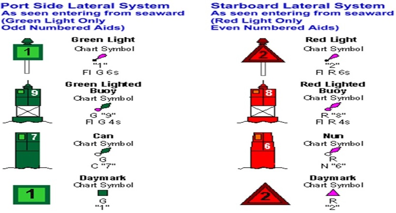
When travelling along waterways, buoys and markers are the "traffic signals". They identify dangerous or controlled areas, and give directions and information. As stated by the U.S. Coast Guard, there are lateral and non-lateral markers in the U.S. Aids to Navigation System. Lateral markers generally indicate which side of an aid to navigation a vessel should pass when channels are entered from seaward. Should there not be a route leading from seaward, the conventional direction generally follows a clockwise direction around land masses. Here are chart symbols from the U. S. Aids to Navigation System:

Definitions of Symbols:
Beacon: Any device designed in a fixed manner in the water or adjacent land (structure constructed of pilings, etc.), which is used to convey a message of navigational aid to watercraft operators.
Buoy: Any device designed to float which is anchored in water and is used to convey a message, the exception being a mooring buoy, which is used to moor a watercraft. A buoy's shape and color, red or green, allows boaters to follow a safe course on the water.
Can & Nun: A "nun buoy" is cone shaped on top, red in color, and marks the channel on the right when proceeding inland from sea. "Can buoys," named because of their cylinder-like shape (green in color), mark the left side of the channel.
Daymarks: These can be a sign on a post, or they can be on the shore. They are also red or green depending on which side of the channel they are on. They also have odd or even numbers. Red have odd numbers and green have even numbers.
Regulatory Markers:
Regulatory or informational markers are used to advise boat operators of situations, dangers, or directions. They may indicate shoals, swim areas, speed zones, etc. They can be easily identified by the orange bands on the top and bottom of each buoy.

Controlled Area: Type of control is indicated in the circle, such as slow, no wake, anchoring, etc.

Danger: The nature of danger may be indicated inside the diamond shape, such as rock, wreck, shoal, dam, etc.

Boat Exclusion Area: Explanation may be placed outside the crossed diamond shape, such as dam, rapids, swim area, etc. (Source: Safe Boating)
"Having a safe and enjoyable day on the water means more than just packing the family, friends and refreshments into the boat. Knowing the meanings of the U.S. Navigation System is crucial to keeping everyone safe, not only the operator and his/her passengers, but also others enjoying Florida's waterways. We are presenting here some of the information which boaters need, but by no means is it all the information required. We recommend that boat operators, whether they are new to boating or are 'seasoned' boaters, take a boating course and refresh their knowledge before venturing out in their boats," says Attorney Spivey.
The following is a list of websites where boaters can obtain maps of local waters and find information on boating courses.
Marco Island Sail and Power Squadron
Sanibel-Captive Sail and Power Squadron
San Carlos Bay Sail and Power Squadron
Fort Myers Power Squadron
NOAA Office of Coast Survey (electronic navigation charts)
Florida Boating and Angling Guide
Fort Myers Boating Accident Attorney, Randall L. Spivey is a Board Certified Trial Attorney – the highest recognition for competence bestowed by the Florida Bar and a distinction earned by just one (1%) percent of Florida attorneys. He has handled over 2,000 personal injury and wrongful death cases throughout Florida. For a free and confidential consultation to discuss your legal rights, contact the Spivey Law Firm, Personal Injury Attorneys, P.A., in Lee County at 239.337.7483 or toll free at 1.888.477.4839,or by email to Randall@SpiveyLaw.com. Visit SpiveyLaw.com for more information. You can contact Spivey Law Firm, Personal Injury Attorneys, P.A.in Charlotte County at 941.764.7748 and in Collier County 239.793.7748.

